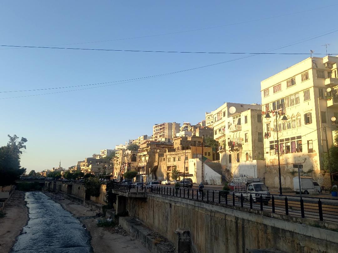
The river, the buildings and its people will tell you the tale of this neighborhood. As the tale starts, you are met with an abundance of free salutations and smiles despite the bleak living conditions and future. The atmosphere is warm and welcoming which is the case in most eastern areas in Tripoli that are known as “popular neighborhoods”. You also can feel the freshness coming from the “Abu Ali” River (1), which is overlooked by “Dahr el-Moghor” (2), or what was left of the exposed river that became a dumping site where excess grass grows and little water seeps through.
Randomness is the main characteristic of “Dahr el-Moghor”, but the neighborhood is not a slum. It isn’t one that emerged at a later time than the heart of Tripoli, nor was it taken over by displaced people from nearby villages and towns or was put up by non-Lebanese refugees. “Dahr el-Moghor” and its surroundings are one of the oldest communities in Tripoli, and the Abu Ali River was the main factor that led to its formation since the Phoenician era, followed by the era of Crusaders who built the Tripoli Citadel “Saint Gilles” that overlooks the neighborhood. At its foot, you could find the shops and markets that the Mamelukes intricately established and managed.
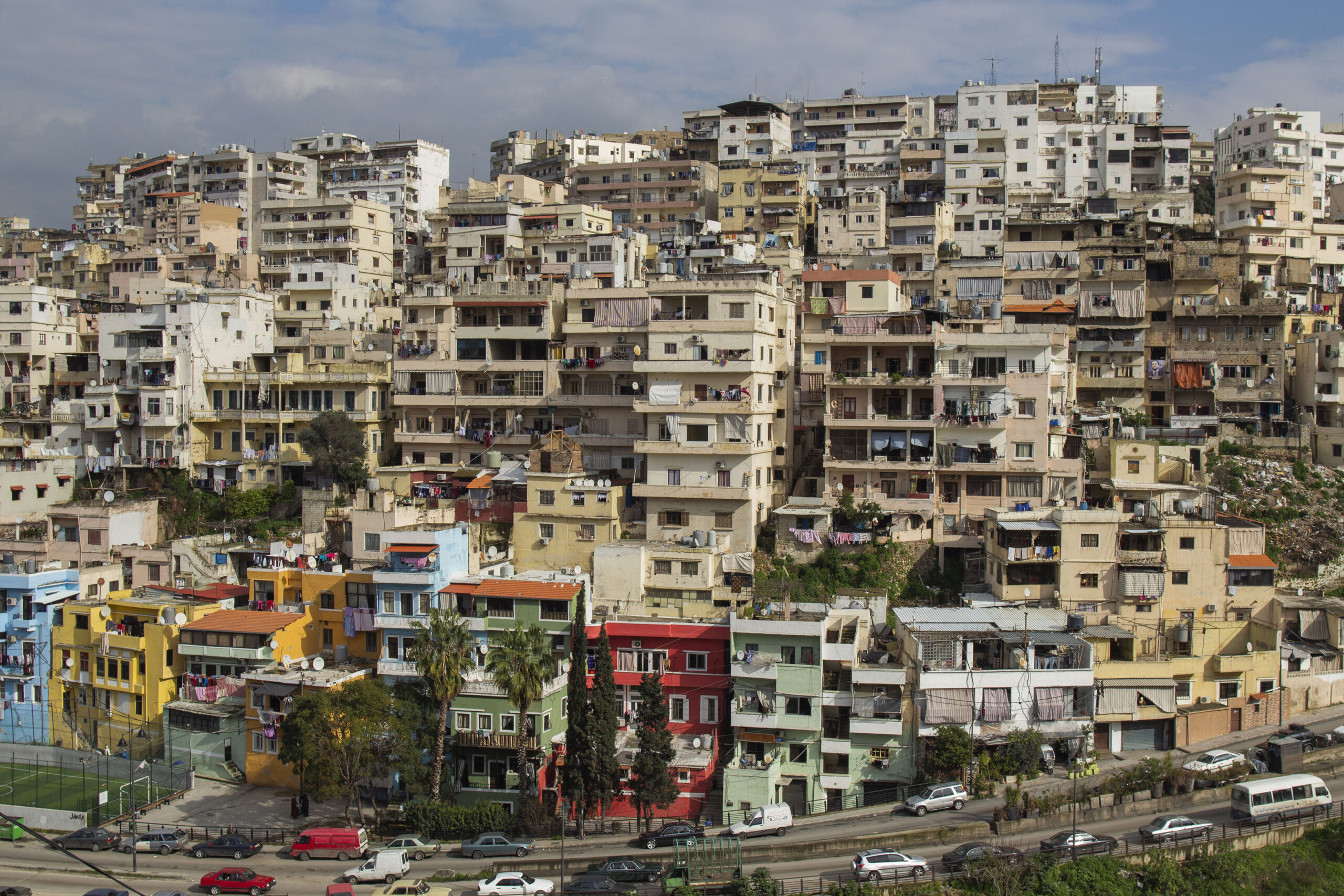
We are also in one of Tripoli’s most populated and-dense areas, where the number of residents reaches around 50 thousand people (3). Misery is clearly invading the area, taking on the form of intertwined buildings hiking the stairs of a broken chaotic and overcrowded hill, without even having reached the outer “Hara” and the Tebbene areas that border Dahr el-Moghor from the west.
The urban morphology of Dahr el-Moghor and its surroundings changed due to several factors, namely natural factors, following the flood of the Abu Ali River in 1955. Just like all neighborhoods that bear the stigma of poverty and that are generally only accessed by their residents, it is no surprise that most people conjure reductionist perceptions of Dahr el-Moghor, most being bad and some rosy. However, in most cases these images are far from reality.
Lebanon: A Special Type of Rent
13-12-2020
Misery might be an old, real, and inherited tale in Dahr el-Moghor, but it is incomplete. You will learn first-hand that you can find among the misery small sparks of happiness and little stories of resilience, which became a sort of social responsibility reflected in the people’s conduct and from their belonging to a neighborhood forgotten just like its people.
Poverty: the stigma of the river and the sea
Let’s be clear: you’re already aware that Dahr el-Moghor is not one of the “fun” neighborhoods, nor one of the “attractive” ones that the small number of Tripoli’s tourists like to visit. These tourists only go to the internal eastern part of Tripoli that stretches between the river’s western side and the city center, “Al Tal”, because they know that Tripoli is the second Mamluk established city after Cairo. You are also aware that few are those who enter Tripoli if they do not live or work in the city - embassies included it on the list of “red borders” for security reasons. Job opportunities are scarce, and so is the number of remaining businesses.
The neighborhood isn’t a slum. It isn’t one that emerged late compared with the heart of Tripoli, nor was it taken over by displaced people from nearby villages or was established non-Lebanese refugees. “Dahr el-Moghor” and its surroundings are one of the oldest communities in Tripoli, and the Abu Ali River was the main factor that led to its formation since the time of the Phoenicians, followed by the Crusaders who built the Tripoli castle “Saint Gilles” that overlooks the neighborhood. At its foot, you could find the shops and markets that the Mamelukes intricately established and managed.
The area was the target of a World Bank-funded tourism project launched at the beginning of the new millennium, to transform the Abu Ali River and surrounding popular neighborhoods into the twin-image of a riverine district in Barcelona! However, the execution became a disaster for the river, due to mismanagement and the absence of supervision. The situation was exacerbated by local political figures taking control of municipal ordinances, which inevitably allowed those protected by them to assume authority over the project, establishing countless taxi garages and car repair shops without restrictions.
You are also aware that objectively, Tripoli is a “Mediterranean city”. Its geographical position today is linked to its most painful characteristic, even if sociologists consider that Gaza is by far “the poorest city on the Mediterranean.”
After a ten-minute drive up north away from the beaches, the sea starts to disappear, but you can still gather fragmented images of the sea stigma inside “riverine Tripoli”. You need to leave your car because roads are chaotic and overcrowded, and you need to take the stairs to reach Dahr el-Moghor, which is why it is rather a wise - albeit mandatory- idea to continue your journey on foot.
Nothing there is “exotic”, not even poverty. If you were looking for exoticism, turn your gaze towards the western part of Tripoli which was mainly known as “Tripoli’s orchards” that used to be stocked with an abundance of all kinds of citrus trees, giving Tripoli the title of “Al Fayha” (the fragrant paradise). These fruits are still named “Mrakbi” (for ships) since they used to be delivered by ship to many areas in the world! Many of these trees disappeared or are about to, but this part of the city remains “exotic” to those who are astonished that Tripoli has the knowledge of a city’s social, urban, cultural and even linguistic development, especially when they assume that all of Tripoli’s citizens live in slums. They mainly heard or saw glimpses of conflicts between “Bal Al Tabbaneh” and “Jabal Mohsen” that erupted shortly after the start of the Lebanese civil war (in 1975), and continued until 2014, opening deep scars, some dating back to massacres committed by the Syrian ADF (4) in Tripoli.
The Abu Ali River’s punishment
Tripoli and Lebanon’s Beirut-centralized state that was established in 1920 have a dysfunctional relationship. In fact, doubting the Lebanese state has become a sort of “identity” for the citizens of Tripoli that is still alive today even if it may seem like it disappeared. Its manifestations are visible in the Dahr el-Moghor neighborhoods and other areas that surround the river just like a belt of misery.
This river is one of the most important indicators about the nature of the relation between Dahr el-Moghor, Tripoli and the authority. Consequently, this relation is bound by persistent injustice and the feeling that the state is completely neglecting the neighborhood and its residents. Expressions such as “the curse of the roof”, “malcontent with the state”, and “they destroyed the river” are voiced by the people of the region if you ever ask them about the river’s story. Before climbing the stairs that lead to Dahr el-Moghor, extreme chaos calls for your attention. The river is strangled by a roof of cement where second-hand markets and carts trying to sell fruits and vegetables have spread, even though across that roof, a vegetable market known as “the wheat market” already exists, with second-hand shops similar to the specialized market that could be found all around Tripoli and that kept its name despite losing their role as the economic drivers of Tripoli’s businesses (5).
Today, between the teetering carts and garbage surrounding them, stands frail palm trees with dying yellow leaves, a harsh example of mismanagement and the absence of planning, which pushes you to ask, how did anyone think that palm trees would survive above a layer of cement?
This distortion was not born in one night, neither was the “erasure” of the river with its urban and public banks. In fact, the area witnessed three main phases over the past seven decades:
The Dahr el-Moghor area stretching towards “Al Bahsa” and the wheat market was part of an ambitious tourism project that was established at the beginning of the new millennium, and that was known as the “Revival of Cultural Heritage Project” funded by the World Bank, to transform the Abu Ali River and surrounding popular neighborhoods into the twin-image of a riverine district in Barcelona! However, the execution of the project was a disaster for the river, due to mismanagement and the absence of supervision. The situation was exacerbated by an authority void and local political figures taking control of municipal ordinances, which inevitably allowed those protected by them and by deputies, the “Qabadayat” (or hardy people) to acquire the authority over the project, establishing countless taxi garages and car repair shops without restrictions.
Measures adopted by the state to address the 1955 flood were practically a curse to the river and surrounding neighborhoods. They showed the people that despite their legacy, interests, and homes, they were simply “invisible”: the riverbed was expanded at the expense of around twenty historical and cultural buildings. The river was also transformed into a deep, water-scarce cement lane. Everything led to the breaking up of the demographic and social makeup, after dividing the river community into separated areas on both banks.
In an earlier stage, during the beginning of the seventies, the region had the opportunity to rehabilitate after the damages caused by natural factors and war. It elaborated a rehabilitation plan , with the supervision of Tripoli’s municipality, and in collaboration with the Lebanese University and the “Mediterranean Cities Rehabilitation Network”. The plan designated 193 sites in the region as historical monuments, however, it wasn’t fully executed.
In the longer run, the distorted relationship between the region and both local and central authorities should be attributed to the “flood”. This refers to the tragic flood of Abu Ali River that occurred on the night of 17 December 1995, and that marked a turning point, erasing the historical value of the region. On that night, the river flow rose to more than six meters, shored up by rain torrents. It is said that the neighborhoods drowned in the waters originating from the land and the skies, sweeping away around 150 victims and tens of missing people. The flood carried away the old bridge that used to connect the two river banks, and hundreds of crafts workshops and furniture factories were destroyed. Witnesses say that on the morning of the following day, they found corpses hanging from trees and others washed out to the shores of Syria after having been carried away by the sea.
However, measures adopted by the authorities were similar to a double “punishment” to the river and surrounding neighborhoods, thus revealing to the people of the region that their legacy, interests, homes, and even they themselves were invisible to the state: the riverbed was expanded at the expense of around twenty cultural and historical buildings (6) that were partially or completely destroyed. All physical and moral traces were erased except for those left in the memories of the region’s builders. The river was also transformed into a cement water-scarce lane (7), which led to the breaking up of the demographic and social makeup of the region, after dividing the river community into separated areas on both river banks.
The “Al Marja” region was not spared. It was known for its abundant greenery owed to the river’s water, and people from different social classes came from the city to visit it as it used to be crowded with cafes and parks. Young people and fishermen used to go fishing in the river flowing with water where children used to swim. People would tell you that in some seasons, they were able to dip their arms in the river’s fresh water from the windows of their homes…
Architectural vulnerabilities
You are now at the heart of Dahr el-Moghor. Despite the overcrowding, the serenity that emanates from the streets surprisingly contrasts with the houses that accommodate more people than they can. Most of these houses are comprised of two rooms where parents live with their children, and sometimes more than one family could be living together.
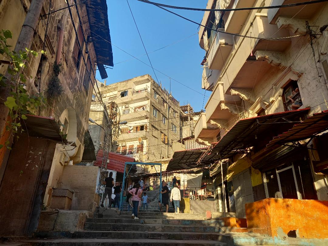
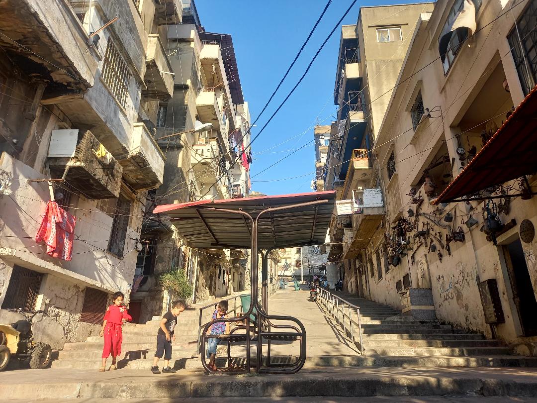
Contrary to the old buildings worn out by the centuries, the streets are filled with a youthful energy. Children play in alleys and on the stairs, games unknown to those who do not spend their times on the streets, such as football, hide and seek, and running races. Amidst one of the stairs, children gather around a wooden swing during the holidays, chanting songs inherited from their parents, while the swing could only hold four children at a time. The swings, just like these homes, are overpopulated.
Children of Dahr el-Moghor witnessed what their peers never did: “Come, let us show you the roof that is about to collapse,” or “we were playing with a ball when we heard a weird sound like chirping, then a crash. The building collapsed and nothing was left of it,” “thick dust, you couldn’t even see your fingers”… they spoke of a child who died under the ruble of her house that collapsed in front of their eyes, while the child was waving at them from the balcony beside her mother. Among these children also, there was a boy who miraculously escaped from under the roof of his room that collapsed while he was sleeping. You can then follow these children to one of the several damaged buildings, and they will show you the cracks and crevices in the cement that they recognize. You can see them clearly from one, two, and three balconies.
“Hajje Fahda” holds and rings a bell in front of houses, so that people know it is time to throw the garbage out. If she’s absent, she’s replaced by one of the children she trained for the job. This street became an exemplary clean neighborhood, decorated by hand-painted vases, and vegetables and flowers. Dahr el-Moghor residents like the fact that they belong to this neighborhood. They work together to survive, and they try as much as possible to “manage what should and can be managed.”
You bid farewell to smiling innocent people who reconciled with the idea of death or who might’ve grown accustomed to the idea of being alive while death was near. You memorize their faces and hold on to the joy you received while taking photos of them. You’re suddenly overwhelmed by the feeling that you somehow want to memorize the children’s features since you’re not sure whether you would meet them again or if one of them was going to become a news story you would rather not hear about.
On the buildings’ thresholds, women sit with their coffee pots and cigarettes, trying to dispose of the burdensome worry, the heat, and the humidity. You ask them about the buildings that collapsed, and they recite the mantra of survival “we live under God’s Goodness”. One of the young men of the neighborhood walks you out while offering a can of “Pepsi” from his store and apologizing for its warm temperature because there is no electricity to keep them cold. Inside the buildings, you are overtaken by a sense of fear, thinking that these are your last moments because a roof might fall or you might slowly die of suffocation from the humidity in the houses that do not receive any sunlight. And you ask yourself, how is it possible to spend a lifetime inside these buildings?
You cannot avoid feeling out of place when you discover that the children, women, and all residents of Dahr el-Moghor do not fear or obsess over a death that could fall upon them at any moment. You might even feel like death is nothing but an absurdity or a “banality” lying underneath the rubble of the buildings. The whole picture feels like a scene taken from Milan Kundera’s novel “The Festival of Insignificance”: “We’ve known for a long time that it was no longer possible to overturn this world, nor reshape it, nor head off its dangerous headlong rush. There’s been only one possible resistance: to not take it seriously.”
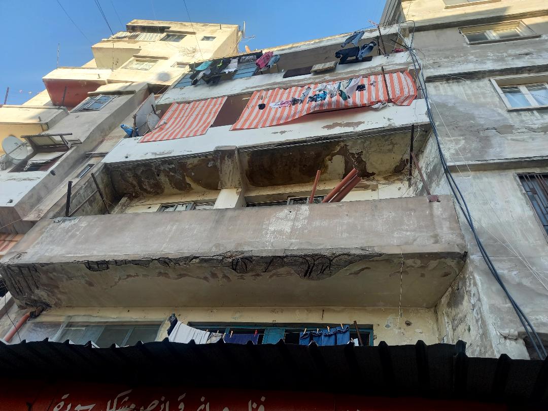
The people of Dahr el-Moghor know that their homes are bound to collapse whether on their own or as a result of the slightest natural threat such as a small or average quake, strong lightning or a slight impact. However, they do not have any substitute shelter. Any attempt to rescue the houses is thwarted by the complexity of property inheritance issues, and the variation in the value of the estate in Lebanese pounds between now and 10 decades ago. Reconstruction attempts through the “Fund for the Displaced” and private reconstruction funds were successful in eliminating the effects of occupation and Israeli wars in the south, but all reconstruction strategies for their own neighborhood fell apart due to negligence or manipulation.
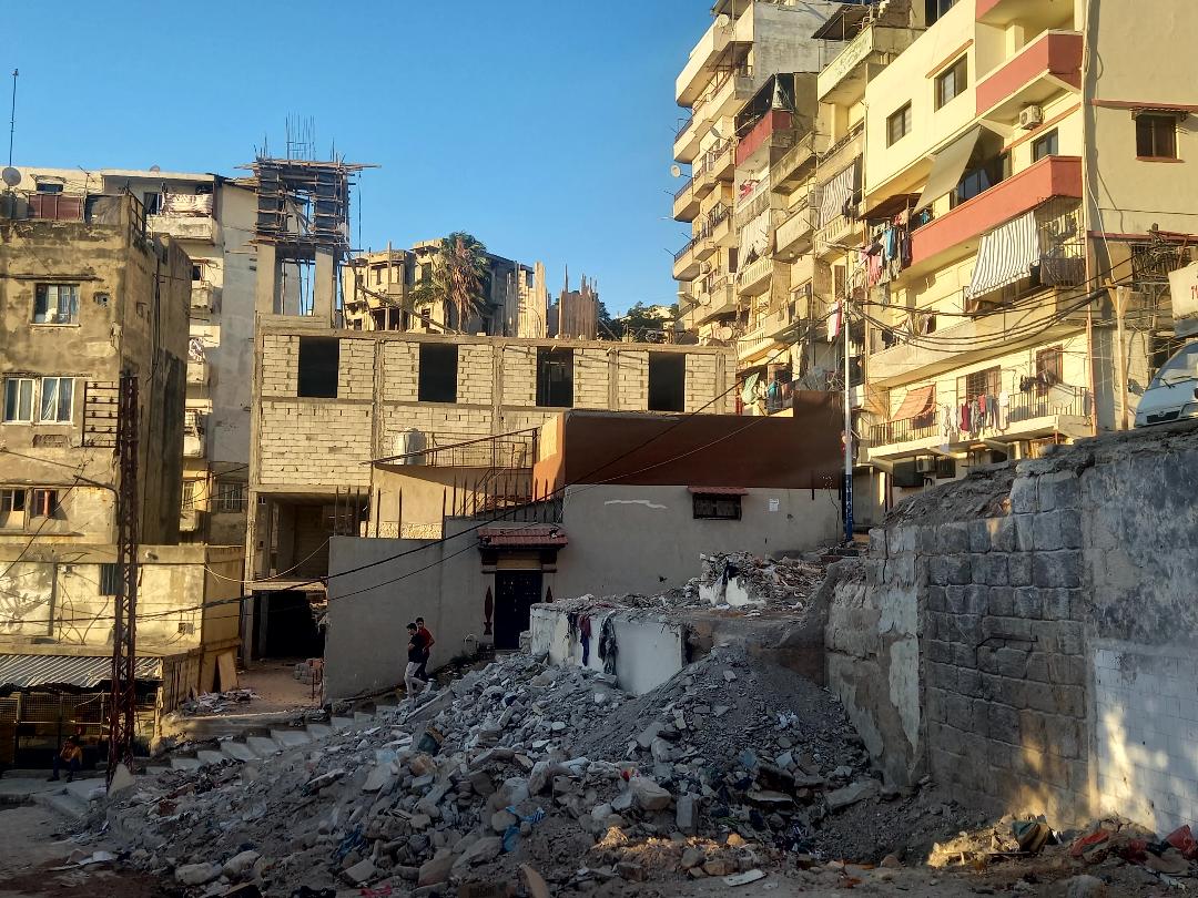
These homes are a mirror to the tightly built, ancient Arab architectural model, where ill-conceived accumulations of limestone are added to a soil that is already moist from the river’s humidity. This leads to feeble walls similar to a crumbling cookie, with a deteriorated base structure and with their skeleton frames sticking out from walls and roofs. During the last century, the houses became an investment for local leaders who wanted to strengthen their interests with perpetrators that belonged to their inner circles who will be later used to mobilize the streets for electoral gains.
Children of Dahr el-Moghor witnessed what their peers never did: “Come, let us show you the roof that is about to collapse,” or “we were playing with a ball when we heard a weird sound. The building collapsed and nothing was left of it”… they speak of a child who died under the rubble of her house that collapsed in front of their eyes, while the child was waving at them from the balcony, in company of her mother.
You bid farewell to smiling innocent people who reconciled with the idea of death or who might’ve grown accustomed to the idea of being alive while death was near. You memorize their faces and the joy you felt while taking photos of them. You’re suddenly overwhelmed by the feeling that you somehow want to memorize the children’s features since you’re not sure whether you would meet them again or if one of them was going to become a news story you would rather not hear about.
The absence of the quality of life in Dahr el-Moghor’s buildings deepens the distorted relationship between the neighborhood and the state with all its entities and institutions, highlighting a social exclusion. This dynamic is prevalent in all of Tripoli, but Dahr el-Moghor is an example of the neighborhoods lying on the northern outskirts of Tripoli, where it is clear that their status is completely different from that of Lebanon, since the greater state has been established and separated Tripoli from its natural environment to bind it to another. The city then became a marginalized space, except for administrations reforms and roads built during President Fouad Chehab’s mandate. However, the Greater Lebanon/Tripoli equation in the popular memory remains similar to a failed transplant operation in a newly created body, and that failure is ongoing. In fact, there is a local proverb that is still relevant in the city that says “including Tripoli in Greater Lebanon is like trying to patch a black Sharwal (traditional pants) with green fig leaves. Neither the Sharwal will become a tree, nor will the tree become a Sharwal.”
All events that took place in Dahr el-Moghor were part of “a scheme put in place by the state with security coverage”, confirms one of the veteran political activists in Tripoli who came from Dahr el-Moghor itself; he’s one of the people who held on the most to the dream of Arab unity, and who spoke up about labor rights and hardworking people in the region whether they were poor or from the educated middle class. The old man tells you about little transparent plastic bags containing drugs he found on one of the stairs that lead to the neighborhood, constantly thrown by young men known to be the right hand of security services and of successive interconnected local leaderships in the neighborhood. The relationship between them and the neighborhood is known by its blatant highlight: “drugging”, whether figuratively through clientelism by providing minimal immediate services and some disregard to violations, or practically by distributing drugs to young men in the region. It is saddening that political activism is dominated by social ills, namely drug addiction. However, at the end, it is the revenge of marginalized people of those who continue to exclude them and invest in their vulnerability. He says: “you cannot ban what is permitted.” But drugs are not exclusive to this neighborhood; they now plague all areas of Lebanon and spread across all social classes.
Social solidarity for survival
A visitor would hate the way of life in Dahr el-Moghor, but he/she wouldn’t help but empathize with its endurance of persistent impoverishment, marginalization, and “looting” on all levels.
While you are getting ready to leave, you will notice that despite everything, Dahr el-Moghor is clean. The neighborhood is truly clean despite the shortcoming in municipal administration and its waste management which is a phenomenon witnessed all over Lebanon.
These homes are a mirror to the tightly built, ancient Arab architectural model, where ill-conceived accumulations of limestone are added to a soil that is already moist from the river’s humidity. This leads to weak walls similar to a crumbling cookie with deteriorated base structure and with the skeleton frames sticking out from walls and roofs. During the last century, the houses became an investment for local leaders who wanted to strengthen their interests with perpetrators belonging to their inner circles who will be later used to mobilize the streets for electoral gains.
The misery weighing down on the neighborhood is permeated by sparks of “social adaptation”, a sort of social responsibility to maintain cleanliness within this realm forgotten by the state: on the stairs, women and men clean the floors in front of their houses; in a remote corner, young people have just finished emptying the stores’ trash from using basic tools for there are no containers, and they stand waiting for a garbage truck to take the trash away.
Theoretically, Dahr el-Moghor might be “less dirty” than surrounding markets where trash, leftover vegetables, meat and chicken with unpleasant smells accumulate, and this is in deep contrast with Dahr el-Moghor that is known to be a residential neighborhood in which most people inherited their homes from their families and kept living in them despite their susceptibility to collapse.
The misery, the past, the present and possible collapse of buildings weighing down on the neighborhood are permeated by sparks of “social adaptation”, reflected in the form of social responsibility to maintain cleanliness within this realm forgotten by the state: on the stairs, women and men from Dahr el-Moghor clean the floors in front of their houses. In a remote corner, young people have just finished emptying the stores’ trash using basic tools for there are no containers, and they stand waiting for a garbage truck from the company “Lavajet” to take the trash away.
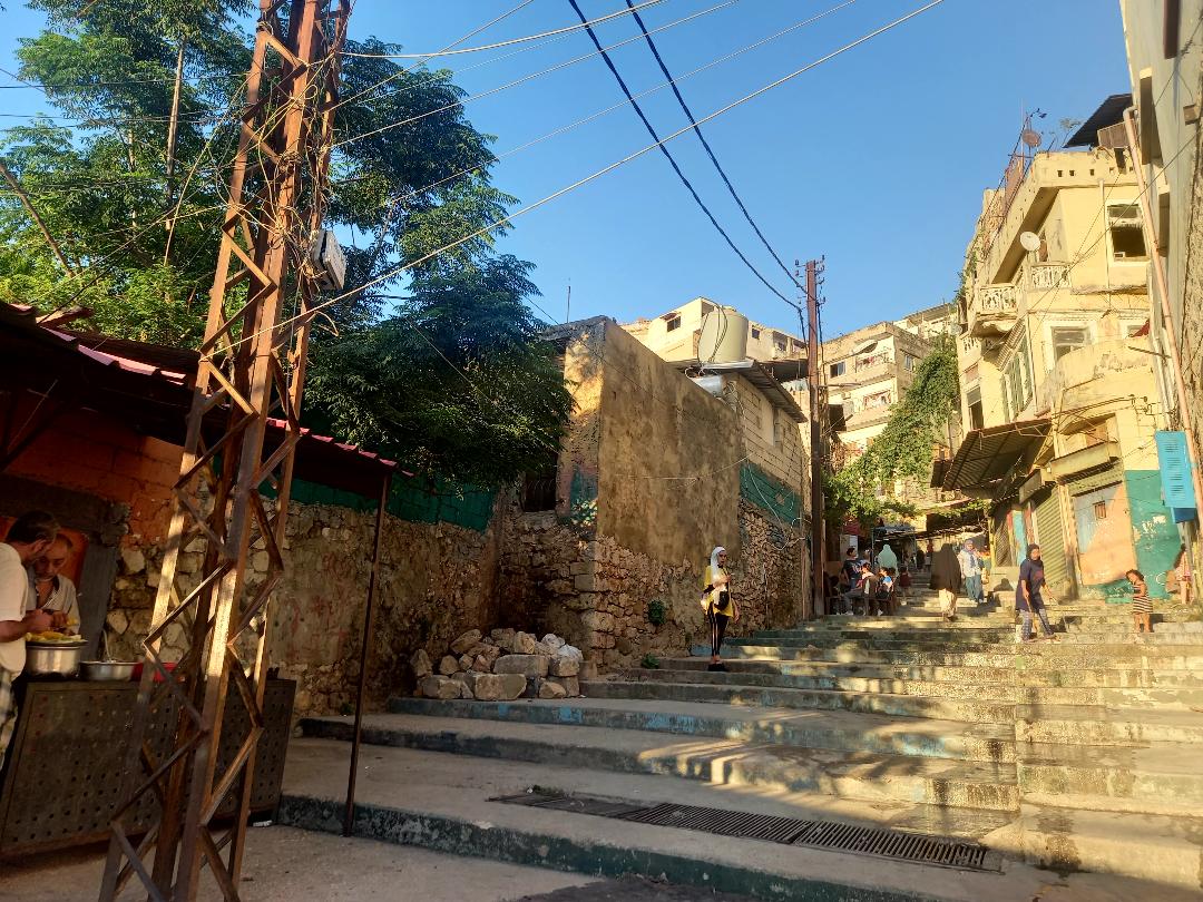
Women and children share the task of keeping the neighborhood clean, as they have been trained by “Hajje Fahda”, an energetic woman from Dahr el-Moghor, with whom residents became accustomed to throwing the garbage at a certain time in the evening. She holds and rings a bell in front of houses, so that people are reminded it is time to throw the garbage out. If she’s absent, she’s replaced by one of the children she trained for the job.
This street became an exemplary clean space, decorated by hand-painted vases and with vegetables and flowers lined on both sides.
Dahr el-Moghor residents like the fact that they belong to this neighborhood. They work together to survive and they try as much as possible to “manage what should and can be managed”.
You are about to leave Dahr el-Moghor, while its fragmented and stubborn images and secrets are still on your mind. You ask yourself: did you not feel that time here flows more easily, in contrast to it being slow? As if time was just these grains of sand fleeting from an ancient hourglass broken a long time ago, and if ever fixed, time would just stop. This neighborhood gives you an overwhelming desire to delve deeper in Tripoli’s relation with time… Tripoli that grows old yet stands still in time.
1- The river stems from the Qadisha Cave at the top of the mountain near the Cedars forest area. It is recognized by that name in the valleys where it flows until it reaches the outskirts of Tripoli and becomes the "Abu Ali River". There must be an interesting story for the name, which we will try to explore in an upcoming article!
2- It is one of Tripoli city’s hills. Perhaps the name points to the presence of caves at the heart of the hill, on the back of which residential buildings were built.
3- According to mayoral election records in 2018.
4- The Arab Deterrence Forces entered Lebanon in 1976 by a decision of the League of Arab States. It was composed of several Arab nationalities until it became rapidly and exclusively limited to Syrians.
5- They depended on abundant local production of citrus, berries, olives, soap, sugar cane, wheat, silk, and local textiles, in addition to an active trade with the Arab World, including Indian and Chinese goods that caravans unloaded in Tripoli, such as medicines, spices, and cloth.
6- Among them, we mention examples not limited to: the Tanners Mosque and the Zariqiyyah School, along with the Zawiya (corner) of Prince Saif al-Din Kartai al-Saifi, the Wattar Mosque in al-Dabagha, the Sibt al-Attar School, the Nisr Ibn Ajbour School and the Arab Bimaristan, the Bath of Estadmor known as al-Hajeb, the Bath of al-Attar in the Mallaha area, and the al-Nuzha Bath under the Lahamin Bridge, the Khan of the house known as the Prince’s Palace, which dates back to the Fatimid era. The General Directorate of Antiquities uprooted its eastern façade after numbering its stones and placing them inside the castle to rebuild it again following the completion of the river project. Ghanem's pillars with huge arches, which were to the west of the Al-Burtasi Mosque, were also removed. The Ottoman Palace of Mahmud Pasha and the Shaara Gate were removed, and the Mevlevi Hospice, the mills, and the waterways and stanchions were destroyed, including the Sabagh Sabil that is located in the area of the slaughterhouse, the Daman School near the slaughterhouse, the old slaughterhouse and the Al-Bahsa Café, the Patriarchal School, the Qattan School, the Khan Asin-Dummar, the Asin-Dummar factory, and the Zahiriya School were destroyed. The Al-Suwaiqa Bridge, Al-Lahma Bridge, Tarabay Bridge, and the palace of Prince Al-Tantash, which is one of the oldest Mamluk palaces, were removed, and three old palaces were destroyed in the Dahr Al-Maghr stairway – according to the archive of historian Khaled Tadmuri.
7- Water became completely scarce after the construction of dams on the riverbeds in areas higher than Tripoli.
All photos were captured by Joudi Al-Asmar
This article has been translated by Al Majaz in collaboration with Assafir Al-Arabi.